You take the readings.
It works out what they mean.
Deflection and tilt computed separately, every drain run measured against the code minimum slope for its diameter, a contour map drawn from your own points, and a plain-language owner summary — bound into one ASCE Level B document an engineer, an adjuster or an attorney can review directly.
It opens in your browser with a worked case already loaded — nothing to install, no account, no card. Monthly · cancel anytime.
Methodology of record
- ASCE Texas SectionGuidelines for the Evaluation and Repair of Residential Foundations, Version 3, adopted 1 April 2022 — a voluntary professional methodology, not a state standard
- IPC Table 704.1 · IRC P3005.3Minimum sanitary drain slope — 1/4 in./ft for 2½" and smaller, 1/8 in./ft for 3"–6"
- Published soil survey dataSoil map unit, shrink–swell potential and plasticity recorded in § 2.3 and carried into the findings
- ZipLevel PRO-2000Instrument, serial and calibration date recorded in every report · ±0.05 in.
The complete document
Read a whole one before you pay us anything.
Not an excerpt, not a mock-up, not a feature list. This is a whole report as the engine produced it — cover, ten numbered sections, the plumbing exhibits, and the property-owner summary bound into the back. Open it, print it, hand it to your engineer and see whether it holds.
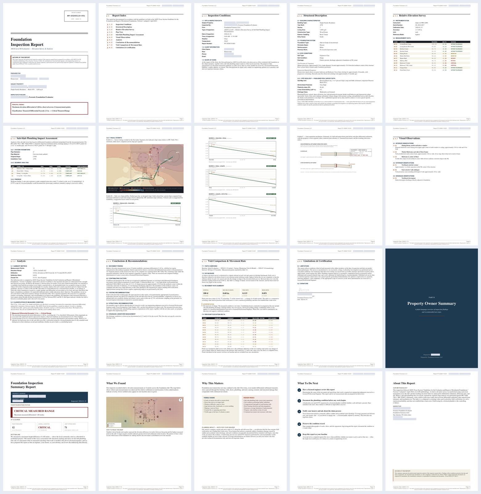
The technical record for the engineer and the adjuster; a plain-language summary for the homeowner. Same report number, same file.
§ 1.0 through § 8.0, with § 3.5 and § 3.6 for plan view and plumbing. Same numbering on screen and in print.
Firm, inspector, licence number, instrument and seal are yours. The sample reads SAMPLE because it was made from demonstration data.
We measured this, we did not assume it
How many points does a proper inspection take?
Nobody publishes an answer to this, so we measured it. We defined one settlement surface with a known drop of 1.60 in., sampled that same surface at ten different point densities, and ran every one through the engine. Same house. Same movement. The only thing that changed was how many readings the inspector took.
| Points | Deflection ratio | Tilt | What the report tells the homeowner |
|---|---|---|---|
| 5 | L/938 | 0.16% | Minor movement — monitoring indicated |
| 6 | L/565 | 0.27% | Significant movement — repair recommended |
| 8 | L/793 | 0.19% | Minor movement — monitoring indicated |
| 10 | L/757 | 0.20% | Minor movement — monitoring indicated |
| 12 | L/469 | 0.32% | Significant movement — repair recommended |
| 14 | L/606 | 0.25% | Significant movement — repair recommended |
| 16 | L/453 | 0.33% | Significant movement — repair recommended |
| 20 | L/435 | 0.34% | Critical differential — immediate attention |
| 24 | L/529 | 0.28% | Significant movement — repair recommended |
| 30 | L/430 | 0.35% | Critical differential — immediate attention |
At five points this house reads as "minor — just keep an eye on it." At twenty it reads as critical. It is the same house. The five-point survey did not find the low corner.
A sparse survey does not fail loudly. It returns a confident, professional-looking number that is wrong in the direction that hurts you — it understates. You tell a homeowner to monitor, and six months later the cracks are worse and you are the person who missed it.
Deflection, tilt and severity recompute as each point goes in. You can watch the number stop moving and know you have measured enough — instead of deciding by feel, or by how late it is.
We rendered the same survey three times: byte-identical output, all three runs. The report you hand over today is the report that comes back if anyone regenerates it. Nothing in it depends on the day you pressed the button.
Method: one analytic settlement surface, corner-loaded, 1.60 in. maximum drop. Sampled on a square lattice at each density, reference mode "highest", rendered through the shipped engine. The dip at 24 points is real and instructive — where the points sit matters as much as how many there are.
Who built this
A cedar shop in Selma that kept running into the same problem.
HAKOYA LLC has built custom cedar structures for homeowners and businesses around San Antonio since 2022, and registered as a Texas limited liability company in 2025. Working on and around residential foundations is how we came to the problem this software solves. Inspectors and contractors already know what they found before they leave the property — what costs them their evening is the write-up.
Nobody has bought it yet. You would be the first, which is exactly why it is worth being hard on it. Tell me where it is wrong and I can still change it for one person — that will not be true later.
HAKOYA LLC · Selma, Texas · admin@hakoyallc.com
If you want the long version
Every claim on this page, worked out in full.
The method, the regulatory boundaries, the calibration, the monitoring maths, what the tool refuses to conclude, and the audit published against our own releases. It is long on purpose — but it is a second page, not the front door.
How to get it
Priced against one job, not against a spreadsheet.
Report Agent
- Paste your readings and field notes
- Confirm firm, inspector, license, instrument and date
- Finished ASCE Level B PDF on your letterhead
- Plain-language owner summary included
- Runs on Capafy — nothing to install
Renews automatically. Cancel anytime.
Evaluation Platform
Talk to us
For crews running monitoring intervals — email and we will set it up with you
Single file, v3.5.0 — data stays on your device
- Everything in the agent, plus:
- Live calculation as each point is entered
- Multi-visit monitoring with movement rates
- Per-segment field-test evidence (CCTV, hydrostatic, smoke)
- Raw-data CSV export for P.E. review
- Runs offline — no install, no account, no server
No free trial. You do not need to try it — you need to read what it produces. The sample above is a complete report, and the preloaded demonstration is the working tool with data already in it.
See the report before you decide.
There is no trial, because there is nothing to try out — there is something to read. Open the sample above, or the preloaded demonstration, and judge the output on its own terms.